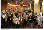
 The second day started early and switched over to what the conference called ‘self-organised’ talks where those who have something to say can put up a title and summary of their talk and see who would sign up for them. Last night, a whole bunch of topics were put forward for consideration and throughout the night, delegates were voting. The more popular the talk, the more people will sign up for them. The boring ones got zilch. Quite democratic in my view and kept up with the very self-help, ‘doaucracy’ nature of this conference. The top ten (or so) choices were then split across 6 different rooms across five time slots. Yes, I can count – some talks were repeated while empty slots were used for social chat and networking. Additionally, there was a technology demonstration area in the main foyer of the conference hall with people milling around.
I attended a number of these self-organised talks: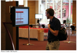
‘Making Crisis Mapping data information actionable for the humanitarian community.’
‘Best practises for verifying crowdsourced data’
‘Google Mapping Tools. What’s new? Q&A and Brainstorming’
I don’t want to go through a complete regurgitation of the above talks (they are available on the Crisis Mappers site) – but I can summarise some as follows:
Making crowdsourced data, ‘actionable’ remains a problem. While everyone is familiar with twitter, facebook etc. Representatives of ‘user’ organisations, especially the major UN agencies such as the World Food Programme (WFP), UNICEF etc, say it would be very unlikely that they would rely solo on crowdsourced data to trigger relief actions. Certainly crowdsourced data would give a strong corroboration to more established lines of communications and could speed up the pace of actions. For example, tweets (if they’re geocoded) could give strong evidence of a specific event with a geographical property. Very useful for speedily allocating resources for example. However, it is unlikely that an international response will be triggered off by a single tweet or a million tweets. There are major issues around the standard of data collected via crowdsourcing. Data collected gives an indication of something but not the priorities. The utility of crowdsourced data as an exploratory tool was readily acknowledged.
Conclusions
- We must be accountable for data we are gathering and taking action on it.
- The use of social media might change the way humanitarian agencies work by making them accountable to the beneficiaries through rapid feedback. Once you increase understanding and knowledge within the beneficiaries, and increase the quality of information, you increase their ability to articulate how they evaluate the impact of humanitarian agencies.
- The goal of a map is not the map itself; it’s the data behind it. What created it and how it is represented. Maybe we need to look into sorting the data differently?
Verifying crowdsourced data. Can one trust crowdsourced data? A great example of trusted crowdsourced data is OpenStreetMap (OSM) – where tens of thousands of users each can edit any part of the OSM map with their work being peer reviewed, probably in real time. However, th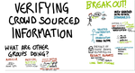 e thrust in the talk was the more well known crowdsourced data sources which are very subjective in nature. Examples include tweets, short wave radio and SMS to name three. Questions over quality, accuracy and ‘trustfulness’ were all explored. One cannot verify and QA a tweet, can we? Thus the problem of event-driven data, ephemeral in nature; very fluid and subjective in content poses significantly problems to decision makers. However, if this data is geolocated (many can be), if there’s 1000s of tweets from one area, if all are about the same event (told through the eyes of the tweeter) – surely this is significant?
Conclusions:
Verifying data from unknown sources, essentially collecting data from those who shout loudest or longest does fill most GIS professionals with dread. It isn’t empirical enough. In many cases, the inability to verify the data, in terms of accuracy, known standards and comprehensiveness isn’t an issue. The data occurred and the value of the data is that it is being generated and therefore an indication of some event in a specific time and place and therefore worthy of inclusion as part of the overall decision making.
My own thoughts:
The entire event was a success with all participants hungry for their work to be mainstreamed and accepted into the humanitarian practise. GIS and intelligent mapping was evident throughout the conference with everyone aware of the utility of having a location or place to link up a wide variety of ephemeral crowdsourced data. Data and information remain big topics as everyone tries to grapple with the well known issues of access rights, ownership, data standards, interoperability, quality and in the case of social media, trust.
The International Network of Crisis Mappers is the largest and most active international community of experts, practitioners, policymakers, technologists, researchers, journalists, scholars, hackers and skilled volunteers engaged at the intersection between humanitarian crises, technology and crisis mapping. The Crisis Mappers Network was launched by 100 Crisis Mappers at the first International Conference on Crisis Mapping in 2009. This website has since been accessed from 191 different countries. As the world’s premier crisis mapping hub, the Network catalyses communication and collaboration between and among crisis mappers with the purpose of advancing the study and application of crisis mapping worldwide.
 The purpose of ICCM 2011 Geneva was to bring together the most engaged practitioners, scholars, software developers and policymakers at the cutting edge of crisis mapping to address and assess the role of crisis mapping and humanitarian technology in crisis response. Following the myriad of responses to the Haiti 2010 earthquake, the crisis mapper community is fanning out into new domains. A number of reports highlight a great deal of excitement over the potential of Information and Communications Technologies, new social media as well as crowd-sourcing to strengthen planning and delivery of aid.
Oh, Willow from Geeks without Borders took notes as on her iPad and to be honest, her notes are far, far better than mine!
Enjoy!