Esri UK Young Scholar 2018 - Jess Hepburn

Each year Esri UK runs a competition for young GIS users. The recipient of the Young Scholar award wins a trip to the Esri User Conference in San Diego, including flight and accommodation. Not bad. The 2018 winner was Jess Hepburn from Newcastle University. Below is her write up of the trip:

In April, I submitted a Story Map titled ‘Geovisualising Environmental Impact Assessments’; this explored the work I completed in my undergraduate dissertation and how this led on to my current PhD work. When I received the call that I was successful I felt a whole series of different emotions – excited, nervous, motivated, and overwhelmed. But, nevertheless unbelievably eager to be one of the 16,000 attendees at the 2018 Esri User Conference in San Diego. I am going to tell you my top five moments I had whilst attending the UC.

Once I arrived in San Diego and had settled down by gaining my bearings and stocking up on some snacks, the Education Summit began. I collected my badge and started to make my way over to the hotel. The first stand out moment for me were the workshops held at the Education Summit. These either 30 or 60 minute sessions gave me an understanding into areas of the programs that I hadn’t considered. Which included Insights for ArcGIS, transferring data from ArcGIS Pro to Online and creating dashboards using data from Survey123. The information from these sessions was invaluable as it allowed me to fully understand how the Esri platform would be able to help support my current PhD research work as well as engage with stakeholders and the general public. The Education Summit was also a great opportunity to speak to the fellow recipients of the Jack Dangermond Young Scholar Award as well as academics and students from around the world.

Jess1.JPG

After a busy couple of days at the Education Summit it was then time for the main event… THE ESRI UC, with over 1000 sessions, 450 hours of GIS training & 300 exhibitors! But, before all of that started was my second stand out moment; The Plenary, led by the President of Esri, Jack Dangermond. This was an experience I will never forget, the hall was massive, full of screens covered in maps and GIS-users from across the globe. This session lasted all day and it really captivated me, making me realise how much of an impact my work can have and how applicable GIS is across the world in nearly every discipline. Some of the guest speakers were really inspiring; including Felix Finkbeiner who set up at the age of 9 initiated Plant-For-The-Planet in 2007. His aim is for children to plant 1 billion trees to offset their own carbon emissions. He had harnessed the power of GIS to make an incredible difference, contributing to saving our planet.

The Plenary was followed by the Map Gallery, which was the third stand out moment in my time at the UC. This provided an opportunity for me to show the poster I submitted along aide the other Young Scholars, interact with other attendees to discuss my work and look at 100’s of stunning maps submitted to the Map Gallery. This was a fantastic networking opportunity, I spoke to people from all over the world about my work (and gaining some great connections on LinkedIn). As well as chatting about the GIS education I received at Newcastle University and my PhD program through the DREAM CDT.

Jess2.JPG

Throughout the week I attended a vast number of sessions. Using the app, I was able to jam-pack my days from 8:30am – 5:30pm with a variety of sessions, discovering the expo and learning new skills through the digital workshops. This gave me an insight into the abilities on the Esri platforms as well as the capabilities and applications across a number of different sectors from exhibitors from across the globe. My fourth stand out moment was attending the Cartography sessions which reaffirmed my current knowledge and opened my mind up to exploring more of ArcGIS Pro. It introduced me to the MOOCs which are free from Esri to help improve and engage key cartography skills – I’ve signed up for two to complete over this academic year.

Jess3.JPG

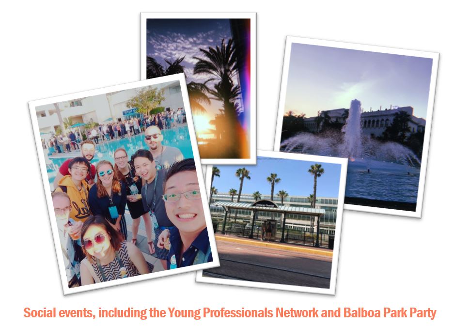
As well as all the fantastic academic and informative opportunities, there were some great social events that were my fifth stand out moment. The Young Professionals Network (YPN) allowed for interaction with young GIS professionals from around the world. It was interesting to meet a wide variety of people in a fun and fresh environment. There was great upbeat music, food and company! On the Thursday night, a party was held at Balboa Park; which was massive. The park contains a variety of museums, all open for free – with music, drinks and food from different areas of the world. It was great to explore with the fellow young scholars, with a good dance at the main stage - ending the week perfectly. Overall, I had a once in a lifetime experience in San Diego at the Esri UC, it opened my eyes to so many new possibilities and demonstrated how highly GIS is regarded across the world. I would like to thank Esri UK for this fantastic opportunity and would recommend anyone to apply!


Geo Jobe Admin Tools for ArcGIS Online

Geo Jobe Admin Tools for ArcGIS Online

As the use of your organisations ArcGIS Online you will need to perform tasks to manage your users and their content. Geo Jobe Admin tools for ArcGIS Online help you perform bulk actions to users and items and will save you time. In this article we will look at some of the useful tasks such as deleting users and migrating content between users.

Read More

2017-20 Esri Chest Agreement

The 2017-20 Chest Esri Agreement is a little different to previous ones. The new licence agreement provides access to the majority of core components of the Esri platform with the options controlling the number of users that can have access. The table below summarises the user allocation for each licence option.

 2017-2020 Chest Options

 2017-2020 Chest Options

Essentially, your university has a "pool" of user and it can provide them access to a range of core Esri products such as:

  • ArcGIS Online - including Survey123 / Collector
  • ArcGIS Desktop - ArcMap and ArcGIS Pro
  • CityEngine
  • Esri E-Learning 

You can check which licence option your university is on using this map.<INSERT MAP> 

Managing your Licenses

As Esri transitions it's users to the new Named User licence model there are multiple ways to provide end users with access to Esri software.  The table below summarises the different option licencing models available.

LicenceTable.PNG

The number of licences deployed by a university should not exceed the allocation of the licence option they are on.  For example, if a university were on Option B they would have 1000 licences to deploy.  The following may be an acceptable approach.

  • EFL (CU) – 800 licences deployed across open access machines and roaming desktop profiles

  • ESU (SU) – 100 Licences deployed to staff members machines

  • EVA – 100 Licences to be given to students to enable them to run ArcMap on their own laptop without having to connect to university network

It is important that you do not exceed the user quote associated with your licence option.

Named Users

Named Users will become the licensing method for all core Esri products.  At the moment we would hope that any Esri user in your university is provided with a Named User identity so that they can access ArcGIS Online and apps such as Survey 123.   Named users are managed through  ArcGIS Online and there will be a blog post on how best to manage named Users soon.

What’s new in ArcGIS Online since the December Update?

The December 2016 ArcGIS Online update has just taken place providing many minor updates as well as some the new functionality and features. In this blog we will look at some of the updates which the Education Team think are of most interest. If you want to find out a bit more about all the changes that have occurred, please use the ‘what’s new help’ document.  

Analysis

  • Join Features has been added into ArcGIS Online as an analysis tool. This is a capability many people have been waiting a while for and a something that we are very excited about. Joining features will allow you to transfer attributes from one layers or table to another, based upon a spatial or attribute relationship.  
  • A new Find Outliers tool has also been added to the Analyse Patterns tool set. It allows you to create maps showing any statistically significant clusters and spatial outliers present in the area. 

Hosted web layers

  • The ability to publish OGC-compliant WFS layers from an existing hosted feature layers in ArcGIS Online has been added as a capability.  Additionally, you can now access hosted tile layers as OGC Web Tile Map Service (WMTS) layers.
  • You can also create multiple views of a hosted feature layer allowing you to publish the data once, then create tailored views for each audience. Everyone would be looking at the same underlying data but with different capabilities enabled. 

Web Apps

  • Story Map Journal and Story Map Series now support dragging and dropping local images from your computer directly into the application.
  • The configuration pane in many of the apps has been redesigned.
  • New themes have been added to the Basic Viewer, Elevation Profile and Map Tools applications.
  • There have been many minor updates to Web App Builder but some of the most substantial updates are:
    • A new Extent Navigate widget has been added for navigating the map to its previous or next extent.
    • You can now add data layers from groups and local files, including shapefiles, CSV, GPX and GeoJSON.
    • The Basemap Gallery now has the option to synchronize with the basemap gallery settings of the organisation.                                                                              

Map Viewer

A new lightweight expression language has been introduced into web maps in this release. This is Arcade and it allows you to write expressions to style and label features in the map.

Organisation Administration

You may have noticed on your My Organisation page that the users have been classed as level 1 or level 2 members. In summary, level 1 users can view content shared with them, but cannot create, own or share content. A level 2 user can view, create and share content. Please see the levels, roles and privilege page for more information. 

Did you hear the one about Landsat, Amazon Web Services and Esri?

Did you hear the one about Landsat, Amazon Web Services and Esri?

Finding the right satellite image can sometimes be tricky, you have to find the right portal, understand the file naming convention and find an image from the right time period that is not obscured by cloud. Well things just got easier with Amazon Web Services and Esri's Unlock Earth's Secrets website.

Read More

Jack Dangermond Award 2015 - Patrick's story

Each year, Esri Inc run the Jack Dangermond Young Scholar award. Each of the global distributors run their own competitions and send the winner out to the User Conference in San Diego.  It's a great prize, the winner gets return flights, accommodation, a free pass to the whole UC and we even throw in some spending money.  But it's bigger than that, it is an opportunity to network with other early career academics, to meet key Esri Inc staff, and of course meet Jack. In 2015, Esri Uk awarded the prize to Patrick Rickles, a PhD student at UCL - this s Pat's story:

A month or so ago, I submitted a research poster to Esri UK to compete for the Jack Dangermond Young Scholars Award and the chance to represent the United Kingdom at the Esri Education User Conference and the Esri User Conference in San Diego, California. I was absolutely thrilled to find out that I’d won and would be going to the biggest gathering of experts from my industry. This also enabled me to confirm two presentations I was slated to give – one on my research on Teaching GIS to Interdisciplinary Researchers (with GIS Lessons for You) and another on the work Challenging RISK is doing.

This morning kicked off the main event – the 2015 Esri User Conference! This part of the conference took over the entire San Diego Convention Center, with a total of over 16,000 people in attendance! Jack Dangermond kicked things off and shared with the crowd his vision, and the conference theme, of Applying Geography Everywhere. Indeed, Geography is a great integrator discipline and many problems have spatial complexities to them; I think given the growth of our industry and new economies that are emerging in the way of enhancing our experiences of the world around us, GIS is going to play an even bigger role in our world.

Jack

Check out Jack’s keynote and the rest of the videos from the Opening Plenary at GISCafe

We also had the opportunity to have a preview of the features and functionalities of new web capabilities of Esri Technologies and a first look at ArcGIS Pro – very exciting. A talk followed on the application of GIS to Wildfire Management, which is very important to saving lives and homes. The day’s plenaries closed out by Governor Martin O’Malley, discussing how GIS was used to reduce crime and manage city assets, when he was the mayor of Baltimore.

Afterwards, the other young scholars and I met at our posters in the Map Gallery to be there to answer any questions people may have. Of course, I had to take a cheesy photo with mine:

I still can’t thank Esri and Esri UK enough for the opportunity to attend; it was an absolutely brilliant event!


Collecting data in the field as a group using Collector for ArcGIS

Collecting data in the field as a group using Collector for ArcGIS

Collector for ArcGIS enables you to collect field data in a group. Everybody in the group has access to the same data form and all the data is automatically collated in your ArcGIS Online account.  Sounds like it will be hard to set up, but it really isnt and with the workbook included here all you have to do is follow the instructions. You could set up your own group data collection activity in less than 30 mins.

Read More